
Page 20 - FCW, September 15, 2016
P. 20
MAY 2000
THE OPENING
UP OF GPS
In May 2000, President Bill Clinton authorized the removal of a security feature from the Global Positioning System — a decision that opened the doors to accurate geospatial data for thousands of government and consumer applications.
The presidential order dramatically improved the accuracy of satellite- based navigation by turning off Selective Availability — a dithering function designed to intentionally distort GPS timing and positioning data.
The feature had been added to block uses of the GPS system by enemy actors, but it was discon- tinued when the Defense Department concluded it was no longer needed. Without it, the margin of error for civilian uses of the satellite system sharp- ened from 100 meters to less than 20 meters.
Thenew,moreaccurate GPS started a boom in the market for geolocation applications within and outside government. Today GPS technology is embed- ded in devices as varied as cell phones and snow- plows and used in indus- trial applications ranging from construction to sup- ply chain management.
Even before the GPS
system was opened up,
federal agencies had been
busy designing new civil-
ian applications. In 1997, NASA began experimenting with the use of GPS receivers to pinpoint within a few feet the exact position of a space shuttle, aircraft or individual on the ground.
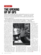
At the National Oceanic and Atmo-
spheric Administration, surveyors were testing the use of GPS to main- tain the integrity of some of the fed- eral government’s architectural trea- sures. In summer 1999, NOAA teamed with the National Park Service to use GPS to measure micro-scale shifts of
the Washington Monu- ment’s foundation.
Throughout the 1990s, the Federal Aviation Administra- tion pursued GPS in its search for ways to conduct more precise airplane approaches in less time and under poorer weather condi- tions than ever before.
And as geospatial data powers an ever- growing range of gov- ernment missions, the accuracy of the data continues to improve as well.
In February, for example, research- ers at the University of California, River- side’s Bourns College of Engineering devel- oped a method for using a device’s own inertial measurement
unit to deliver centimeter-level GPS location accuracy. That advancement could be hugely important for auton- omous vehicles, mobile phones and precision agriculture technologies, researchers said. n
The Commerce Department’s Dave Ward checks the alignment of the GPS receiver atop the Washington Monument.
20 September 15, 2016 FCW.COM
NOAANEWS.NOAA.GOV
