
Page 31 - GCN, March and April 2017
P. 31
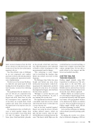
Using Pix4D software, Michigan state police officers upload photos with GPS data and create 2-D or 3-D models of accident scenes for further analysis.
ment received clearance from the FAA to use a drone over the entire state, and it was one of the first law enforcement agencies to do so.
Two FAA officials came to Michigan to go over paperwork and conduct practical exercises with the department before granting the operational certifi- cate of authorization.
The first test of the Aeryon SkyRang- er, which the state police paid for with funding from the Department of Home- land Security, occurred the following month.
The quadcopter flew its maiden voy- age over the site of a suspected arson in Jenison — “coldest day of the year,” Rogers told GCN. Since then, he said fire investigators have requested use of the drone on a regular basis. Crash analysis and crime scene footage join fire inspection for the top three uses, he added.
The department relies on Pix4D soft- ware to stitch together images from fires or car accidents. It can create both 2-D and 3-D images. Using GPS, of- ficers place black-and-white placards
on the ground to find their exact loca- tion. That information can be uploaded to Pix4D to allow investigators to take measurements from the images.
“This technology is crazy,” Rogers said in describing the imaging capa- bilities that officers now have at their fingertips.
The Michigan State Police has since bought and fielded one more drone with another trained pilot. A third is be- ing prepared for deployment, and there are plans for even more. It’s a welcome development for Rogers, who had been the lone drone operator.
“Michigan is a pretty big state, and I was driving everywhere,” he said. “I was running all over the state.”
The department has also invested in a downlink truck that can live stream video from the drone or a helicopter via a secure internet site.
And as for that cornfield fugitive? Rogers was using the drone’s forward- looking infrared camera, which can pick up heat sources, when he spot- ted Huddleston crouching between the rows. The drone’s initial flight over the
cornfield had not revealed anything, so Rogers flew it higher and pointed the camera straight down. He was able to guide officers to the suspect, and the arrest was handled smoothly.
A BETTER TOOL FOR
TRACKING WILDLIFE
Finding tagged animals using VHF transmitters is nothing new. The tech- nology dates to the mid-1960s, and federal agencies such as the Fish and Wildlife Service and the Forest Service have used them for decades. But it’s not always the most efficient approach.
Michael Shafer, an assistant profes- sor of mechanical engineering at North- ern Arizona University, said VHF signals can bounce off topographical features or be obstructed by objects as common as a tree. That can make the process of finding tagged wildlife more difficult and time-consuming, he added.
So he and his colleagues are building a drone-based system for picking up the signals.
By placing the receiver on a drone, they’re effectively designing a 400-foot
GCN MARCH/APRIL 2017 • GCN.COM 31
PIX4D
