
Page 14 - GCN, March/April 2016
P. 14
EMERGING TECH
BY PATRICK MARSHALL
Satellite image analysis scales with deep learning and crowdsourcing
ONE OF THE FEW remain- ing things humans can still do better than machines is recognize patterns in images. Unfortunately, humans aren’t very fast at processing mas- sive amounts of imagery.
DigitalGlobe, a provider of high-resolution Earth imagery and analytics, processes 4 million square kilometers of satellite imagery every day. “There aren’t enough intelligence analysts in the world to put eyes on every piece of data that we collect,” said Tony Frazier, a senior vice president at DigitalGlobe.
The company’s solu- tion? Use the best of both machine and human capabilities.
According to Frazier,
the company has been training a combina-
tion of deep learning
tools — NVIDIA graph-
ics processors, the Caffe deep learning framework and the OpenCV computer vision and machine learning software library among them — to take the first pass on its imagery and identify objects and activities. The objects might be fixed infrastruc- ture, such as buildings and bridges, or movable items, such as helicopters and airplanes. Activities might be events such as wildfires or flooding.
He said government clients are interested in
achieving “a high recall and moderate precision,” so as long as the program catches 90 percent of the objects being looked for, “even if there are a number of false positives, they are OK with that. We’re not trying to be perfect. We’re trying to nar-
the company can call on a community of more than 1 million volunteers to validate data after events, such as the recent earthquake in Nepal. “Less than two weeks after that event,” he said, “we had north of 60,000 volunteers who had put eyes on over
bytes of content, upwards of 50 gigabytes,” Frazier said. “You need to be able to turn that into more bite-sized chunks of information.”
That’s where MrGeo comes in. The program was jointly developed by Digital- Globe and the National Geo-
12 GCN MARCH/APRIL 2016 • GCN.COM
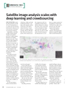
This satellite image of Nepal after the 2015 earthquake shows damaged roads, and demonstrates DigitalGlobe’s use of crowdsourcing to supplement machine
bridges and buildings — learning.
spatial-Intelligence Agency and built on Apache Spark and the Hadoop ecosystem. MrGeo handles the storage, processing and slicing of imagery files so that they can be moved to Amazon Web Services for analytical pro- cessing by the deep-learning algorithms on hundreds of commodity computers.
“The elasticity of the cloud allows us to get a lot of computers working on a problem,” Frazier said. •
row the search space.” Frazier added that the
deep-learning algorithms, which run on the company’s Geospatial Big Data plat- form, are already delivering the level of performance required by clients. Further- more, the algorithms get better as they learn, he said.
And one way they learn is by being reinforced by humans through crowd- sourcing.
According to Frazier,
1 million tiles of imagery
to do things like damage assessment. And all of that learning goes back into the system to make the machine learn over time.”
The machine and human analyses of imagery are the final stages of DigitalGlobe’s processing of satellite imagery. First the imagery must be sliced into digestible chunks of data.
“A single image from our satellite has multiple giga-
TOMNOD.COM
